 Ancient secrets of the New Forest have been revealed thanks to high-tech images beamed back by lasers from aircraft.
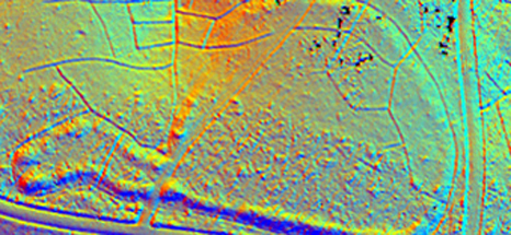
More than 3,500 new archaeological sites and monuments have been uncovered in the New Forest National Park, including prehistoric field systems, Bronze Age burial mounds and an Iron Age hill fort with its system of bank and ditches.
The research has also shed new light on two Bronze Age barrows on Beaulieu Heath damaged in the 19th century by a local rifle club as they built a target range. The laser mapping clearly shows how misshapen one of the damaged barrows is compared to its neighbours.
Many of these landmarks were hidden under dense forest until National Park archaeologists used a plane to fire harmless laser beams into the ground to build a 3D map of the surface. The Light Detection and Ranging technology (LiDAR) can penetrate the tree canopy, revealing features which cannot be seen by other means.
Combined with more traditional aerial photography, infra-red images and field work, National Park archaeologists have a better idea of how archaeological sites are directly linked and often re-used over the ages.
The New Forest is the first National Park in the country to have its entire landscape surveyed by LiDAR. The survey also mapped surrounding communities – an area the size of 92,000 hectares or 350 square miles.
The public can see the results for themselves online, zooming in to interesting locations at www.newforestnpa.gov.uk/heritagemapping.
Lawrence Shaw, heritage mapping and data officer for the New Forest National Park Authority, said: ‘These resources will allow the public to explore the National Park in a way they could never have done previously. Archaeological sites and monuments can be seen in different ways through different data sets which provide the users with a view completely different from that seen on the ground.
‘These data sets allow users to look at the greater landscape and see how sites and monuments interact with each other on a large scale, as well as being able to see what lies beneath the trees.’
The data was acquired as part of two projects run by the New Forest National Park Authority – a Heritage Mapping Project, funded through Europe’s largest Higher Level Stewardship scheme with the Forestry Commission and Verderers; and the New Forest Remembers WWII project, funded through the Heritage Lottery Fund.
The LiDAR Project has been run for the past three years and uses multiple data sources to identify, record and manage archaeological features found on the open Crown lands of the National Park. The data sets include high resolution LiDAR data, aerial photography and near infrared imagery, all of which is now available on the internet.
The web pages range from a map which allows users to select a grid square of interest and download scaled images of the processed LiDAR data, to three interactive pages that allow the user to pan across the national park and see how it looks from the air either as a 3D surface model, near infrared imagery and aerial photography.
-ends-
Picture caption: A LiDAR image of an Iron Age hill fort in the New Forest National Park courtesy of Forest Research, Cambridge University Technical Service and New Forest National Park Authority.