 A high-tech approach used to identify over 3,000 archaeological sites in the New Forest is one of the archaeological innovations of the last 50 years.
The New Forest was the first National Park in the country to have its entire landscape surveyed by Lidar, which stands for Light Detection and Ranging technology.
Now this technique has been nominated in Current Archaeology magazine’s Archaeology Awards 2017. Lidar is one of the Archaeological Innovations of the Last 50 Years, with the New Forest National Park Authority’s heritage mapping project identified as the best example. A public vote is open until February to crown the winner – vote now at www.archaeology.co.uk/vote
The National Park team’s use of Lidar involves beaming harmless lasers down from light aircraft to form a 3D map of the landscape. Unlike conventional aerial photography, this innovative approach allows experts to see below trees and shrubs to identify previously unrecorded features.
Since 2010, this has seen the project record and protect thousands of sites, including significant finds such as prehistoric field systems, an Iron Age hill fort and World War II bomb test sites.
The project is funded by the New Forest Higher Level Stewardship (HLS) Scheme, a 10-year agreement with Natural England worth £19m. The scheme is held by the Verderers of the New Forest and managed by them in partnership with the Forestry Commission and the New Forest National Park Authority.
Through the heritage mapping project and other initiatives, the survey has mapped the National Park and surrounding communities – an area the size of 92,000 hectares (125,000 football pitches).
Lawrence Shaw, Heritage Mapping and Data Officer for the New Forest National Park Authority, said: ‘The creation of the New Forest in 1079 produced a unique situation where archaeological sites have been almost frozen in time, mostly free from pressures such as intensive modern farming techniques and urban development.
‘As a result, Lidar has enabled us to find fantastically well preserved sites that have been undisturbed for hundreds, if not thousands of years. We have been able to peel back the layers of the New Forest’s history and see how it has been shaped by human activity from the Bronze Age all the way through to World War II. We are now seven years into a 10 year scheme and we are still discovering and learning a huge amount, while also ensuring these sites are preserved for years to come.’
To cast your vote for Lidar and the New Forest heritage mapping project visit www.archaeology.co.uk/vote.
-ends-
Significant Lidar discoveries
- World War I training trenches near Lyndhurst
- Bronze Age burial mounds near Burley
- Iron Age fortified enclosure near Brockenhurst
- Major World War II bombing target and bomb craters at Ashley Walk
Notes to Photo Editor:
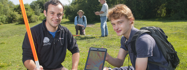
Lawrence Shaw, Heritage Mapping and Data Officer, left, surveying Lidar results in the New Forest with volunteers.
Photos of significant Lidar discoveries are available on request.
Notes to Editor:
1. The role of the Verderers of the New Forest is to protect and administer the New Forest’s unique agricultural commoning practices; to conserve its traditional landscape, wildlife and aesthetic character, including its flora and fauna, peacefulness, natural beauty and cultural heritage; and to safeguard a viable future for commoning. www.verderers.org.uk
2. The Forestry Commission is the government department responsible in England for protecting, expanding and promoting the sustainable management of woods and forests and increasing their value to society and the environment. www.forestry.gov.uk/england-about-us
England’s Woods and Forests are cared for by Forest Enterprise England, an agency of the Forestry Commission. www.forestry.gov.uk/englandsforests
For more information, visit www.forestry.gov.uk/newforest
3. Natural England is the government’s advisor on the natural environment. Established in 2006 our work is focused on enhancing England’s wildlife and landscapes and maximising the benefits they bring to the public. www.gov.uk/natural-england
4. The Environmental Stewardship Scheme, of which HLS is one strand, is administered by Natural England, on behalf of Defra, and funds farmers and land managers throughout England to deliver effective environmental management on their land.
The objectives of Environmental Stewardship are to:
- Maintain and enhance landscape quality and character
- Protect the historic environment and natural resources
- Conserve biodiversity.
- Promote public access and understanding of the countryside
The ES scheme is now closed to new applicants and has now been succeeded by the Countryside Stewardship scheme
5. The New Forest National Park Authority works with partners to conserve and enhance the natural beauty, wildlife and cultural heritage of the National Park and to promote opportunities for understanding and enjoyment of its special qualities. It also has a duty to foster the social and economic well-being of local communities within the Park. www.newforestnpa.gov.uk
Media Contact
Matt Stroud
Engagement and Interpretation Officer
New Forest HLS Scheme
Matt.stroud@newforesthls.org
01590 646650