What are the issues?
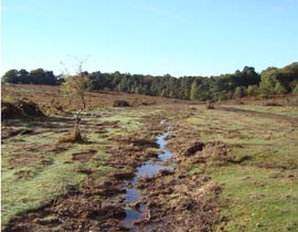
 Claypits Bottom was in ‘unfavourable declining’ condition due to successive drainage works that were undertaken during the last 100+ years, and more recently in the 1960s.
What was once a large mire is now a combination of drier habitats near the drainage channel, with localised mire in low areas of the valley.
The steep gradient of this valley has also caused the straight drainage channel to continue to erode into the underlying clay, and through scientific study has been proven to be once of the fastest eroding channels in the New Forest. As such, this channel is continuing to deepen, and locally to widen as well, resulting in a significant loss of material downstream.
Unlike elsewhere in the New Forest, there has been one benefit of these past drainage activities. The continued erosion of the drainage channel has exposed a clay horizon in which marine fossils have been found which are of national geological importance. Any restoration proposal needs to balance the need to restore the overlying habitats whilst maintaining and safeguarding the underlying geological feature.
How have we fixed it?
In 2010 the bed level of the incised drainage channel was infilled to within 20cm of bank height for a significant length (as agreed at consultation with stakeholders). The bed level at the geological end of the SSSi was ramped down to the eroded watercourse using heather bales. At the downstream end a new gravel ford crossing was created and the damaged bridge which had previously served as the access point across the stream on a Restricted Byway was removed from the site.
The results of this restoration have been; a reduction in the loss of material downstream as erosion has been reduced, becaue water ia now able to escape from the channel under high flows (thereby reducing energy). The shallower restored watercourse has raised the water table locally, giving it a better interaction with it’s floodplain. By stepping down the infill in the area of geological interest, the majority of the geological exposure remains accessible with the rest sensitively conserved beneath infill material. Further geological survey work (as directed by Natural England) will guide the restoration specification in this area, as well as recording and cataloguing the geological features in detail. This condition assessment of this SSSi unit is now rated as ‘unfavourable recovering’.
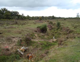
See picture after restoration below.